Geekzone: technology news, blogs, forums
Guest
Welcome Guest.
You haven't logged in yet. If you don't have an account you can register now.


David321

507 posts

Ultimate Geek
+1 received by user: 105


#320357 4-Aug-2025 14:18
Send private message

Hi all, 


My wife and I live next a large paddock in Rolleston, I figure the owners have the large property with the pool. 


Our subdivision is just a few years old and the developers have roads leading up to their paddocks to line up with roads on the other side, its obvious they have future proofed with the assumption that they will sell the land one day and then the roads can connect.


Currently the driveway to the big house runs a very long way down along the back fence of all the properties to the bottom right of the photo, and there are many more out of the picture. When and if they sell their land I don't see any viable access to their house as the roads that look as though they will be connected through their paddocks one day would cut across this driveway.


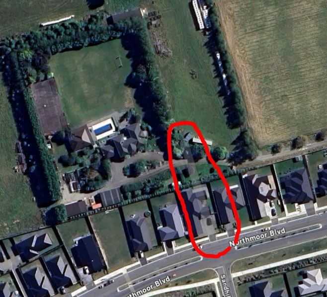
Today I noticed that google maps have updated their aerial imagery and street imagery and there is a faded line through one property, it gives me the impression it's perhaps supposed to be a road, but has not been built yet, the thing is it goes through a house and all of the houses on that street are less than 3 years old.


I am curious if perhaps the owners of that large house sell their huge paddock if they will be given a driveway through this house (knock the house over), I doubt it, but given the circumstances there could be a very small chance that is the plan?


The big house I am talking about is located near the corner of Frogmore Way and Northmoor Boulevard Rolleston - if anyone is keen for a look.


_David_

Create new topic
Quinny
926 posts

Ultimate Geek
+1 received by user: 208

Trusted

  #3399877 4-Aug-2025 14:26
Send private message

I'm in Rolly and moved in 14 years ago. I was told the House opposite me would be a road if a subdivision behind it happened. Over the years, it has never happened, but it has shown on some maps. With layout changes since (Goulds Rd), I can't see it ever happening that way now. Check the title you got when purchased, and Selwyn Council can be good if you pop in to answer stuff like that.  


tripper1000
1648 posts

Uber Geek
+1 received by user: 1176


  #3399934 4-Aug-2025 15:58
Send private message

My parents driveway also features like that on Google Maps. 


Definitely not a future road in their case.  


Bung
6733 posts

Uber Geek
+1 received by user: 2926

Subscriber

  #3399951 4-Aug-2025 17:30
Send private message

Why would they need to demolish when there's another empty section?


snj

snj
305 posts

Ultimate Geek
+1 received by user: 221


  #3399963 4-Aug-2025 18:37
Send private message

Similar is happening around West Auckland, it becomes quite stark when looking at, for instance, https://basemaps.linz.govt.nz/@-36.8151836,174.5934489,z15.22,p8 


Each of those strips of land coming off Fred Taylor Drive seemed to be managed by different development companies, so personally I'm on the assumption that the various councils, given the land has been earmarked for development opportunities have a master development plan that the various developers have to fit their designs around (obviously with some flexibility). Contacting the relevant planning departments would likely get a copy of those to see the overall roading vision.


KiwiSurfer
1722 posts

Uber Geek
+1 received by user: 993

ID Verified
Lifetime subscriber

  #3400037 4-Aug-2025 20:29
Send private message

Does the council in that area have their own GeoMaps service like Auckland has? May be able to find some clues there.


Wheelbarrow01
1784 posts

Uber Geek
+1 received by user: 2638

Trusted
Chorus

  #3400051 4-Aug-2025 22:14
Send private message

KiwiSurfer:


Does the council in that area have their own GeoMaps service like Auckland has? May be able to find some clues there.


Yep - this covers the entire Environment Canterbury area - https://canterburymaps.govt.nz/help/map-viewer/ 


The anomaly the OP mentions is not visible on the ECan map - but neither are any/many of the homes - looks like the aerial imagery for this area is woefully out of date.


The views expressed by me are not necessarily those of my employer Chorus NZ Ltd


Shop on-line at New World now for your groceries (affiliate link).
Jase2985
13732 posts

Uber Geek
+1 received by user: 6205

ID Verified
Lifetime subscriber

  #3400109 5-Aug-2025 10:00
Send private message

Bung:


Why would they need to demolish when there's another empty section?


Because the empty section doesn't lead to the large paddock 


David321

507 posts

Ultimate Geek
+1 received by user: 105


  #3400113 5-Aug-2025 10:27
Send private message

Jase2985:


Bung:


Why would they need to demolish when there's another empty section?


Because the empty section doesn't lead to the large paddock 


The empty section has also recently been sold


_David_

Bung
6733 posts

Uber Geek
+1 received by user: 2926

Subscriber

  #3400114 5-Aug-2025 10:39
Send private message

Maybe the large house owners bought it. The large paddock and the adjacent one already have stubs of Hungerford Drive.


Create new topic


Geekzone Live »

Try automatic live updates from Geekzone directly in your browser, without refreshing the page, with Geekzone Live now.


Are you subscribed to our RSS feed? You can download the latest headlines and summaries from our stories directly to your computer or smartphone by using a feed reader.