

I'm working on a hobby project looking at predicting rain events at my home location. I am curious about the way that the Metservice scales the rain radar images:

How am I supposed to interpret the intensity scale on the RHS?
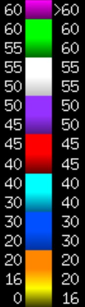
Specifically, while I get the intensity values increase as you move up the scale through the colours, why are there different numbers on each side? Why are some of them the same LHS and RHS, and sometimes they are different?
This is important as I want to correctly map the DBZ value of specific pixels in the radar image to DBZ reflectivity, and I'm not sure how I should be reading the scale and therefore calibrating the lookup tables.
Any ideas?


