Is there any way to show which carriers have services on RCG cellsites? I can't seem to figure out who has what services (if applicable) on which cellsite.
As far as I know it is generally safe to assume if it's a RCG site then any customer of any of the 3 carriers can access all RCG frequencies -- at least for 4G/LTE. I am aware of a couple of RCG sites that have 2100 MHz licenses registered under 2degrees's name (rather than RCG) which I believe may be more to do with voice fallback for older phones that don't support VoLTE and require 3G UMTS for voice calls. I assume these licenses wil be cancelled once 3G is history. All 700/1800/etc licenses currently used for LTE are all registered under RCG and the LTE service isn't ringfenced for a specific carrier or anything like that.
Happy to be corrected if wrong -- above just from my observations.
Is there the potential to have a version of this site for our Australian friends?
Yeah so. I'm anywhere from 2-6 months from having it live. Given I have to deal with two very different data sources I'm taking the time to fix all the things that I've wanted to fix with how I originally did the RSM data, mainly around location/site management.
Multi-layers is one of the improvements that I was able to make with a complete redesign in how I'm managing locations.
Multi-layers is currently a subscriber only feature, but if you're a heavy-ish GIS Geek user next time you login you should be given a trial for a week. If not and you want to give me your email address, DM me and I'll put a trial on your account. Equally if you want to extend it just ping me, just DM me bugs you find :)
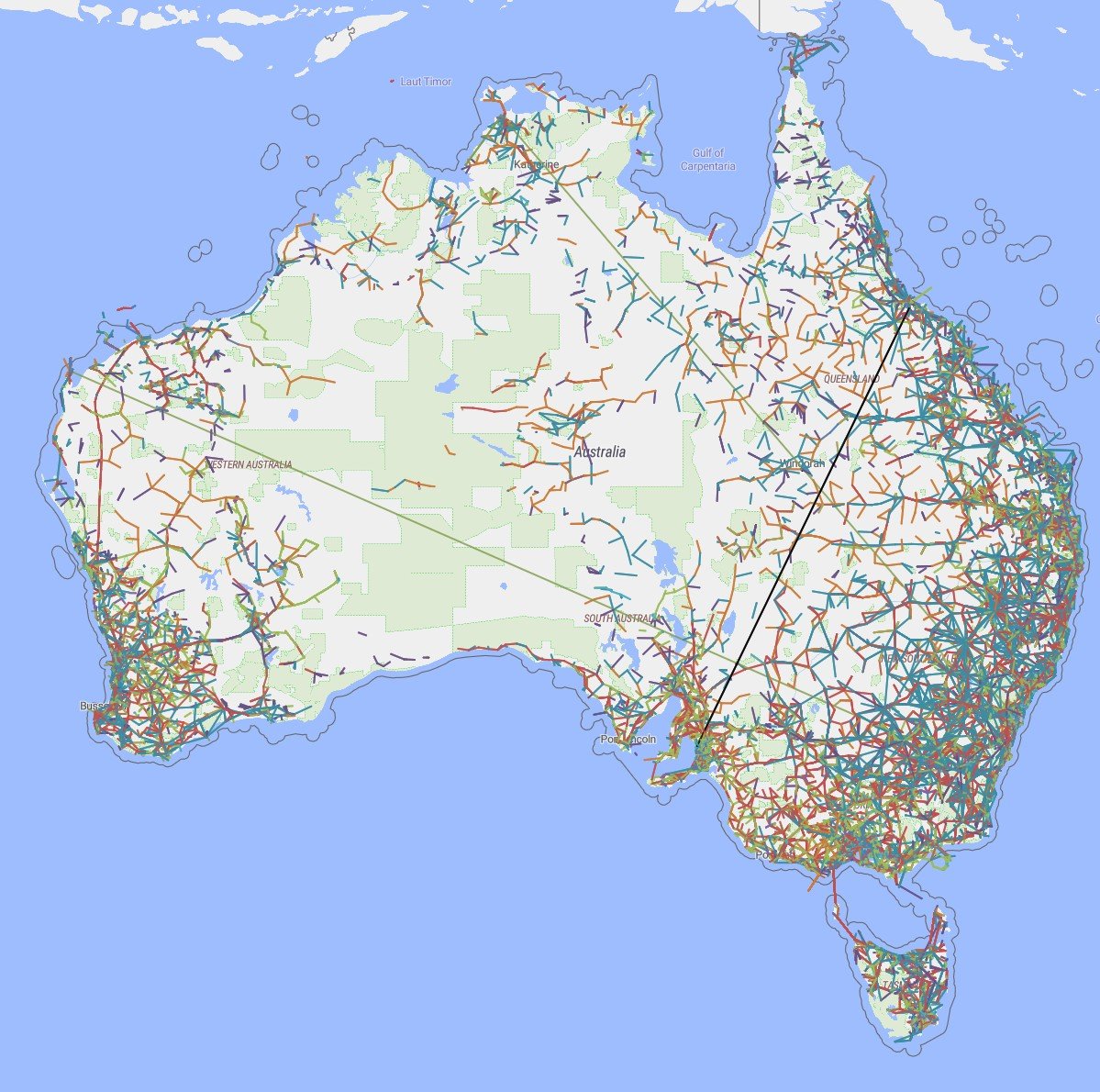
Aussie data is live as well and available to all:
I need to reprocess all of the site location images, that's going to take the weekend.
Your existing login/pass will work on new domain... You'll just have to update your password manager :)
Hi James. I'm new to GISGeek, but have to make a huge shout-out to you for what you have done!
My usage is from a Search and Rescue/Civil Defence perspective, so perhaps this request is more focused in that space, though I suspect it would be picked up by many others.
Have you considered including RF Coverage Maps? For reference Radio Mobile is often used in Search and Rescue, to work out where repeaters, mobile, handheld radios etc. will likely work, and if mobile repeaters are needed and likely places to put them. Radio Mobile has an online HTML interface and an installable Windows program. The Windows program is a 'richer' tool in relation to features. I don't think there is an API as such? Though there are well formatted file formats (though not well documented), that perhaps could be used as an export from GISGeek and import into the Windows version of Radio Mobile if an API or alternate can't be found?
Currently, the typical SAR process is to pull details manually from RSM and enter them into Radio Mobile to generate quick and somewhat 'rough' RF Coverage Maps generated from the Radio Mobile website. (this is for repeaters that SAR/CD have agreements in place to use)
I have access to the RSM API, and have wanted to try to create an export/import from RSM to Radio Mobile, but just don't have the time to progress it at the moment.
Is this something you would consider doing down the track? My link to Search and Rescue is all in a Volunteer capacity, but there are significant Govt. funds spent each year in this area - perhaps that could be something you could benefit from?
Short story - https://github.com/NZRS/wavetrace - Internet NZ have a open source library and last I mucked around with this was ~5 years ago. That was when I was only doing Cell Towers, and it was a waste of time because you actually have no idea from the RSM (licence) data how cell towers are configured, so while it was cool, it effectively generated cool looking fibs.
I have not had a look at doing that again with LMR licences, I'd need to speak to a few people that run some RT repeaters to understand because again, I suspect the licence is the maximum power allowed rather than what the base is actually transmitting on.
Regardless, you should email me (contact is on website). At my day job I work with a 20+ year SAR vet, I've given GPX files to West Coast and Southland members for field work. I can sort you out with an export so you can process the data yourself. Equally, if you give me the parameters you're using on Radio Mobile I might be able to automate something larger.
On GIS Geek, for Spark I only associate 3500mhz with 5G but that was based on the initial rollout. What's people's opinions on expanding that to other frequencies?
On GIS Geek, for Spark I only associate 3500mhz with 5G but that was based on the initial rollout. What's people's opinions on expanding that to other frequencies?
850 MHz - I seem to recall a report here on Geekzone recently where NR n5 was observed in the wild? I think safe to put 5G. Note that Spark has never refarmed this to LTE which makes me think their plan for 3G switch off is to transition all of their 850 MHz spectrum direct from UMTS to NR (skipping the LTE generation entirely). I suspect this will be their plan for nationalwide 5G. I also see NR SA being a possibility with NR 850.
2100 MHz - In Auckland many sites has new Ericsson LTE eqiopment only for L2100 which means Spark needs to keep L2100 as anchor for NR3500 (as it seems not possible for Huawei L700/1800 to anchor for Ericsson NR3500?) so will be interesting to see how they solve that. Out of Auckland however I observe most sites have new L700/1800/2100/2300/2600 gear being used in combination with new NR3500 gear so certaintly possible outside of Auckland to refarm L2100 to NR2100 -- i.e. L700/1800 anchor with NR2100/3500.
2300 MHz - They do own 60MHz of paired spectrum IIRC so they could easily keep 20/40 MHz on LTE and deploy 20/40MHz NR with a long term plan to expand to full 60MHz of NR as LTE demand tapers off. I think quite likely to see 5G in this band sonner than later but haven't seen reports on this in the wild yet.
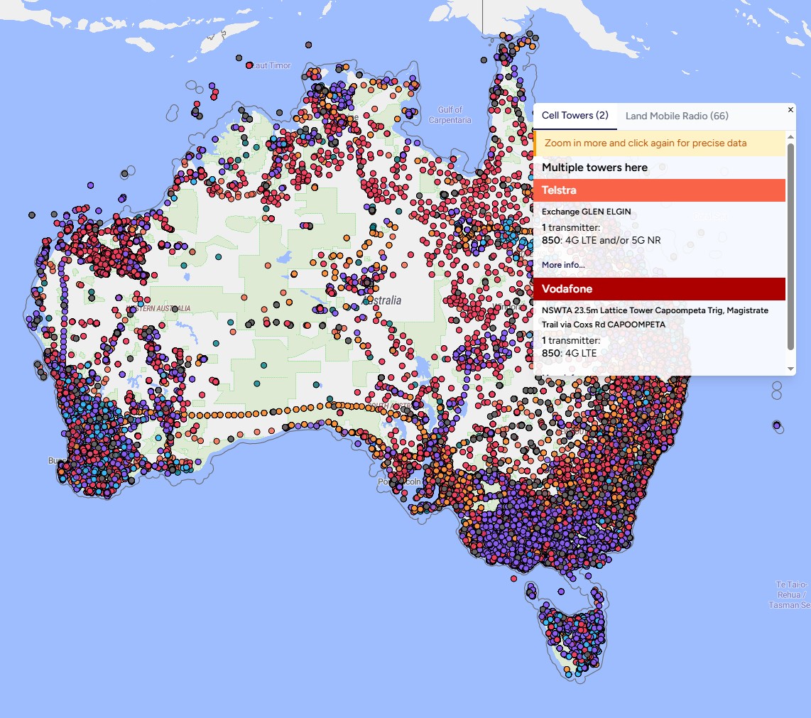
General note - Those who browse cell sites will note I rolled out an update over the weekend to tweak the display of these sites. The main reason for this is due to the ACMA AU data requiring registering of devices, where as RSM only requires licences. This means that often for a combination of spectrum + service there can be 3 devices in AU ACMA data due to having 120 degree sectors, which made the display messy...
Please give feedback, is there something on the old view you preferred? What information (that is possible to present from RSM or ACMA) do you want to see? I think this is a compromise between the two data sets and don't want to go to far one way. I'll be looking at making similar style changes to PTP and LMR viewers over the coming weeks for consistency.
Random nerd side note - While I MUCH prefer RSM's API and very clear data dictionary/structure over the ACMA raw database dump, I definitely prefer Aussies rules that every transmitting device needs to be lodged with ACMA. Check that Telstra Perth link, and click through on one of the Device IDs on the 26GHz mmWave 5G band. The data requirements there are rad, lot more potential for coverage maps. According to the Whirlpool crew though, the accuracy of the data seems to be a lot poorer than RSM...
Also, apologies if you were trying to access the site this morning:
This was all from Google Bot. Every now and then it tends to engage yolo mode and because it doesn't operate like a human, none of the caching works :)
On GIS Geek, for Spark I only associate 3500mhz with 5G but that was based on the initial rollout. What's people's opinions on expanding that to other frequencies?
One NZ have this too on their coverage page:
Our 5G network operates on the following frequency bands: n8 (900 MHz), n7 (2600 MHz), and n78 (3500 MHz)
I have not seen any except n78 for One (and n5 or n78 for spark) although my local tower has a fairly new 30+15mhz licenses for 2600mhz that aren't lit up yet so hoping that's going to be n7
I support adding it! Especially once 3G gets shut off
In the last couple of weeks all I've done is just focus on performance. Lots of query, processing and config optimisation. I've just pushed to production all of the updates and pretty much everyone should notice a significant performance increase across the whole site.
Are you subscribed to our RSS feed? You can download the latest headlines and summaries from our stories directly
to your computer or smartphone by using a feed reader.