stevehodge:
You're getting pretty good sync speeds for VDSL too. It might be good to try to nail down exactly where the cabinet is. You can track it down using the Chorus cabinet list at http://www.chorus.co.nz/file/12279/Existing_Distribution_Cabinet_List_May_2013.xlsx. The coordinates in that file are NZ Map Grid coordinates. You can use something like http://apps.linz.govt.nz/coordinate-conversion/ to convert from NZ Map Grid to NZ Geodetic Datum 2000 which gives a latitude and longitude that can be put straight into Google maps.
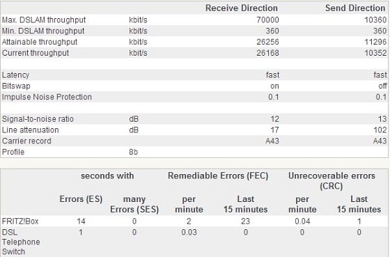
How can I determine which of these is my cabinet? The ones starting with CH are Christchurch presumably, but how do I narrow it down any more than that with converting the coordinate sand plugging them into Google Maps one at a time? Is there a naming convention that they follow?