First off: I'm not a professional artist/3D modeler.
I'm just looking for creating one-time-use 3D models, that I can rotate with a mouse.
The "affordable" lots are less than ideal. One local lot had an 70 degree slope, with storm water outlets in the middle of it, and priced over $200,000. Another needed a driveway, with two hairpin turns, that would cost $100,000 to build.
I want to quickly visualize lots.
I came across "Google Sketchup" , which has a free version.
It can import topology from Google Earth Pro, but their resolution is 15 meters / yards, so no good for a small lot.
Anyhow Wellington city council produces high resolution 2D topographical maps. Resolution is 1 meter / yard.
Anyone tried Google Sketchup, to create a scaled terrain?
--- SOME LINKS ---
http://wellington.govt.nz/webmap/wccmap.html

https://www.landfx.com/videos/webinars/item/2111-sketchup-introduction-to-site-grading.html
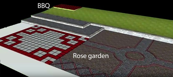
SketchUp is a powerful grading program. The SketchUp Sandbox and Extension Tools are able to generate organic modeling surfaces with relative ease. The tools can be adapted to most models to create conceptual site terrain. Put on your grading hat, and watch how to grade retaining walls, walks, and objects into even the most basic site plan. Learn how to create grading profiles for accessible ramps, steps, roads, and buildings.
The webinar will walk you through the step-by-step process of creating organic surfaces that represent grades and terrain. The tutorial builds on each step and demonstrates different grading typologies and approaches. The method explores the big picture approach to completing a site down to grading details that allow users to incorporate varying site elements, like steps, walls, and ramps, into an overall conceptual grading model for an entire project
https://help.sketchup.com/ru/article/3000132
Creating Terrain from Scratch