![]() ![]() ![]() ![]() |
|
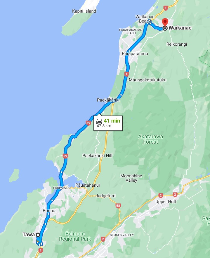
“ "As with many roads through rural areas, there are sections of the new motorway without mobile phone coverage," Waka Kotahi spokesman Andy Knackstedt told the Herald.”
This is a major motorway that is the new route for SH1, Andy, not just some ‘road through a rural area’. FFS.
Sometimes I just sit and think. Other times I just sit.
So does this piece of motorway have its own control room somewhere and emergency vehicles etc like a tunnel ??
Ding Ding Ding Ding Ding : Ice cream man , Ice cream man
Looks like they have built a maintenance centre at the Pauatahanui interchange, in terms of control I believe NZTA oversee the motorway network from an office in Johnsonville so likely will be done from there.
Can confirm the road is now open to the public.
Did Eric Clapton really think she looked wonderful...or was it after the 15th outfit she tried on and he just wanted to get to the party and get a drink?
TG is not showing on Google Maps or Apple Maps. Best route between Paekakariki and Wellington still showing as via Pukerua Bay > Paremata.
I guess it’s going to have to wait until one of their GPS camera cars can get on there.
Sometimes I just sit and think. Other times I just sit.
eracode:
TG is not showing on Google Maps or Apple Maps. Best route between Paekakariki and Wellington still showing as via Pukerua Bay > Paremata.
I guess it’s going to have to wait until one of their GPS camera cars can get on there.
The road is showing for me on Google maps (it wasn't yesterday) but still routing via SH59.
Did Eric Clapton really think she looked wonderful...or was it after the 15th outfit she tried on and he just wanted to get to the party and get a drink?
There is a break in the road at Horokiri Stream, and they are missing two junctions further south.
floydbloke:
The road is showing for me on Google maps (it wasn't yesterday) but still routing via SH59.
Interesting. Re my earlier post, I was looking on iPad - where it doesn't show as an available road. Just checked on iPhone where it shows but not yet in routing, as you say. Google Maps on MacBook shows same as iPhone.
Edit: Just looked again on iPad Google Maps - and it's now showing as an available road. Not showing at all on Apple Maps.
Sometimes I just sit and think. Other times I just sit.
It's definitely appearing on Apple Maps for me. I just tried a route from Wellington to Paraparaumu and it showed SH59 as the preferred route but it showed TG as an alternative. An address in Whitby showed TG as the preferred route.
wellygary:
invisibleman18:
Interested to see if this cuts down the journey time to Waikanae - we live in Lower Hutt.
Presumably you previously went via Ngauaranga?... T/Gully via Pauahatanui will be any interesting time comparison as long as SH58's not a mess..
Usually go via SH58 and SH59 so looks like this should cut out a chunk of that.
Not sure about the other apps, but Waze stores traffic speed data in the road segments, so that will take a few days to build correctly.
Just back from my first drive on it (Whitby to town and return). Impressions:
Heading up to Waikanae tomorrow.
Did Eric Clapton really think she looked wonderful...or was it after the 15th outfit she tried on and he just wanted to get to the party and get a drink?
>doesn't compensate for dumb*ss drivers who insist on doing 80 and driving in the right-hand lane
What can you do with those guys? What could 'compensate' for them?
evnafets:
>doesn't compensate for dumb*ss drivers who insist on doing 80 and driving in the right-hand lane
What can you do with those guys? What could 'compensate' for them?
Snowplows like you see on freight trains.
|
![]() ![]() ![]() ![]() |